
“Keywords are King.” This is the mantra of the online world. If you want to find something, or you want to be found, it all comes down to the keywords you use. For example, if you want to find a restaurant, you go to Google and you search for “restaurant”. But that gives you millions of results around the world, which isn’t particularly helpful. So then you search for “restaurant Sydney” and that filters down the results to a couple of thousand. But you’re actually in Bondi, so you search “restaurant Bondi”. That cuts the results down to a hundred or so. But what you want is a Thai restaurant, so you search “thai restaurant Bondi” and now you’re down to about 20 options. By correctly using your keywords, you’ve narrowed what started as millions of restaurants from around the globe to 20 restaurants in your local area of the type of food you’re looking for.
The reason this type of searching works is that the restaurants have included the relevant keywords as part of their website and online marketing. The business owners and their marketing people have a vested interest in getting the keywords right; otherwise people can’t find your business.
In the world of social media, the use of keywords is less than ideal. Everybody has their own idea of how to describe the content of their posts, and they are unlikely to be looking to sharing their media beyond their immediate audience, that is, their friends and family. Rich media such as photographs and video add another level of complexity – the adage of “a picture is worth a thousand words” rings true here. How then do you find relevant material in social media?
The most effective method is a multiphasic approach: executing a large number of searches using a suite of tools designed to analyse different types of data, coalescing the results and pattern matching across the data corpus to identify the most relevant material. If you didn’t understand that, you probably need to engage an expert. I know a good one.
One of the phases we regularly employ on our matters is a geospatial search. What is it? Instead of looking for “particular content from all places“, you look for “all content from a particular place“. That is, instead of searching the entire web (“all places”) with keywords (“particular content“) you search for all of the content that originated from a particular place on the planet. How does this work? Maybe a picture will help.
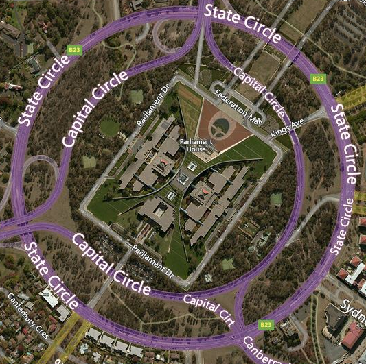
Here is an overhead view of the Australian Parliament House and the surrounding streets. If we wanted to find material about something that happened in Parliament that day, we could go to a news website, or we could search through Google using keywords. Using a geospatial search, we can see what people who were at Parliament House were talking about on that day. Let’s have a look.
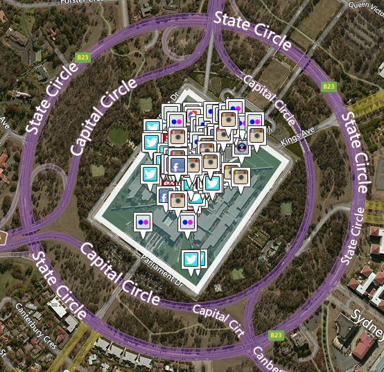
What we’ve done here is to draw a shape around the Parliament House and told this search engine “show me all the publicly available social media posted inside this area on this particular date”. As you can see, there was quite a bit of social media on this particular day, spread across all the major platforms: Facebook, Twitter, Instagram, Flickr, and if your eyes are keen you’ll also see posts to YouTube, Picasa, even a video that was uploaded to Viddy.
How does this work? When you post content to a social media platform from a mobile device (eg smartphone or tablet) that has its GPS turned on, the social platform records the GPS coordinates of where you were when you posted it. If you share that content with the world (ie make it public), those GPS coordinates will be attached to your content. Tools such as the one shown above can read those GPS coordinates and plot them on a map, ready for our searching.
These geospatial search tools are an invaluable part of our methodology. A regular use case is identifying unrelated parties that were in the vicinity of an incident: say a passer-by that took a photo of a motor vehicle accident. That person may be an important witness for our purposes, but are unlikely to have included the keywords that would bring up their content in a Google search. Using a geospatial search around the incident location, and restricting the search to the approximate time of the incident allows us to attempt to identify potential witnesses. This is just one example of how geospatial search can be used, but one in which we’ve had good success.
There are many other use cases for geospatial search, if you’d like to discuss your requirements please get in contact.